More for Less. CEG’s experts combine conventional surveying
with the technology of scanning and aerial mapping to create the best value.
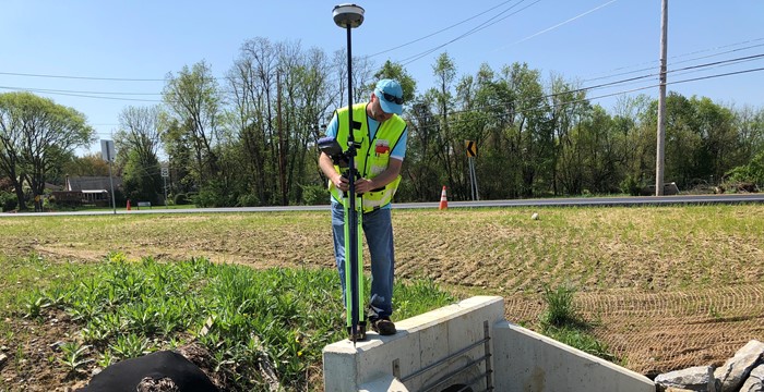
CEDARVILLE Engineering Group, LLC (CEG) has a team of land surveying professionals that includes Professional Licensed Surveyors (PLS), Survey Technicians, and Certified Drone Pilots. CEG’s experienced survey teams offer comprehensive Land Surveying & Mapping Services to the engineering design and construction industry.
EFFECTIVE & EFFICIENT USE OF TECHNOLOGY
Our team of professionals work with you to find the best method of data collection for your project. Whether it’s utilizing our Robotic Total Stations, RTK GPS’s, LiDAR, and/or gathering data via aerial mapping, CEG is committed to meet your budget and precision requirements.
A NEW STANDARD IN AERIAL MAPPING
Capturing data by photogrammetry and/or LiDAR methods from our Unmanned Aerial Systems (sUAS), we can create 3D models to analyze and extract surface and/or planimetric features. CEG has invested in this technology to provide a safer, streamlined, and all-encompassing approach to projects. These 3D models provide a valuable repository of the site conditions that can be accessible to you at all times. All our data is processed and stored in-house, and from these 3D models we can deliver 3D Terrain Models (TIN, DTM, XML, STM or Point Clouds), Ortho-Rectified Imagery, 2D and/or 3D base drawings (in AutoCAD or MicroStation Format), Elevation/Section Plans and more.
SERVICES
• Boundary Surveys
• Topographic Surveys
• ALTA / NSPS Land Surveys
• GPS/Aerial Mapping Control Surveys
• Precision Modeling
• As-Built Surveys
• Subdivisions
• Easement/Legal Descriptions
• Construction Layout/Stakeout
• Flood Elevation Certificates & LOMA’s
• Volumetric/Quantity Surveys
• CAD Drafting and Design
• Expert Witness Testimony
• Forensic Surveys
• Bathymetric Surveys
• Aerial Drone Services
• Aerial Mapping Services
• Aerial Construction Progress Documentation
Contact us today to learn more about these options for your current and future projects! Call us at 610-705-4500 or email info@cedarvilleeng.com.
GIS - Geographic Information System
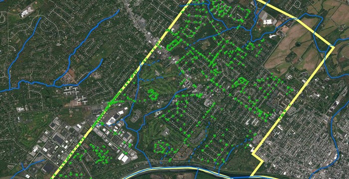
CEG’s team of analysts and scientists use GIS technology to support planning, design, and regulatory compliance for local, federal, institutional, and commercial clients.
Digital maps, relational databases, and spatial analysis tools are used to deliver services that enable our customers to visualize and understand complex issues.
THE POWER OF PLACE
Issues and events that affect communities happen in places. We use Geographical Information Systems (GIS) to display mission critical data, such as roads, stormwater infrastructure, and other physical assets in concert with natural resource data. This allows our customers to see how issues affect their community and visualize impacts of alternative solutions.
SUPPORTING THE BUSINESS OF GOVERNMENT
Our GIS experts are applying GIS technology to support environmental issues, inventory critical infrastructure, design sustainable development projects, and effectively engage citizens. We use GIS to analyze many different types of data simultaneously to determine trends and patterns, perform complex spatial analytics and modeling, and then present information in easy-to-understand products.
TRUSTED EXPERTS
We work collaboratively with our partners and customers to provide the right level of GIS expertise and technology to meet their needs.
SERVICES
• Data Capture & Integration
• Analysis & Modeling
• Support for Mission Programs
• GIS Staff Support & Augmentation
• System Planning & Implementation
• Web Map & Application Development
• Data Capture & Analysis Training
• Geospatial Technologies
• Asset Management
• GIS Integration with 3D Modeling
• Story Maps
• Geospatial Inspection Logs
• On-Call or Subscription Services
CEG uses GIS for municipal, state, and federal government projects. For more information, please call 610-705-4500 or email info@cedarvilleeng.com.